For the second month in a row David Readio, my friend of some 25 years, drove out from his home in Westminster, Colorado this past Thursday night to Osborne, Kansas for a Labor Day Weekend of once more flying around the state of Kansas landing at every public airport. This was Part VII of these series of trips, with Part I occurring in June 2006. The whole thing began then as an Official Explorer Quest by we two Kansas Explorers - Dave, KE #4419, and yours truly, KE #8. At the present time stands at 140 airports. We have taken off on these jaunts whenever we can and when the fickle Kansas weather allows it, and have strived to work around Dave's moving from Lawrence KS to Colorado in 2007. The count at the start of this trip stands at 52 airports so far.
To reiterate, Dave is the Pilot, the Captain of the Ship, and the Master of His Particular Domain. His American Champion Citabria is certainly not the largest plane in the world by far and is in fact often used as an acrobatic plane. At the moment it is housed in a hangar at the Osborne Municipal Airport. I'm along for the ride functioning as the Official Photographer and Backseat Driver.
We arose Friday morning, September 3rd, anticipating landing at no less than 15 airports before the end of the day. Ten is the record number of airports that Dave has done before in a day, so we shall see. A quick Smoothie breakfast at Harvey's Coffee and Kitchen in downtown Osborne at 8:30AM and we arrive at the airport hangar at 9AM.
A check of the plane, the storing of luggage and us, and with the Pilot's And Away We Go! we record a takeoff from the Osborne Municipal Airport at 9:30AM. We head south on the first leg of the journey, the destination for which is Great Bend Municipal Airport.

10:10AM - Things begin to get interesting when we start flying over new territory, reaching the city of Hoisington, which was tragically hit by a tornado in 2001. One of the buildings that survived the tornadic winds was the Hoisington High School, seen at center right.

A view of Hoisington as we fly along the city's western edge. The tornado's path of destruction can still be seen from the southeast to the northwest via the lack of trees in the lower half of the photo.

For several decades Hoisington was a "railroad town," the Rock Island Railroad being the main employer in in the city. The railroad shops and a roundhouse stood at the southern end of town; today only two large structures remain onf the complex. My grandfather Roy Pearce worked here as a pipefitter for many years.

Just past Hoisington we pass to the west of Cheyenne Bottoms, a wildlife refuge that is officially one of the 8 Wonders of Kansas.

Ten miles south of Hoisington we pass to the west of the city of Great Bend on the Arkansas River and the Santa Fe Trail. This shot taken from the northwest is not the usual view people have seen of the city, making all the more interesting.

The Great Bend Municipal Airport is located four miles west of the city. "It was constructed in the early 1940s as a World War II Army Air Force Base to accommodate the B-29 Superfortress bomber. The airfield included three intersecting 8,000-foot long paved runways, taxiways, aircraft park aprons, aircraft storage hangars, and several support facilities to include administrative buildings, barracks, and automobile access roads. Early in 1944, the 58th Bomb Wing took off from the airport runways. After World War II, the airport was transferred to the City of Great Bend, and the City began to modify the facility to better serve civilian aviation." This quote courtesy of greatbendks.net. Gotta love the Internet!

Our American Champion Citabria on the ground (left) at Great Bend Municipal. A great tail wind out of the North allowed us to get here in only half the normal time as we land at 10:20AM. We fill up with gas, enjoy the cool morning air for a bit, then climb back in the plane and take off to the south-southwest at 10:45AM.

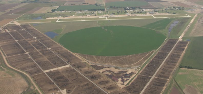
View of the city of Stafford, Kansas as seen from the north. The circle is an irrigated field, for those who are curious.

This view from the west is of Stafford Municipal Airport in the foreground and the city of Stafford 2.5 miles away in the background. Most airports are this far from their communities, making a pilot's ability to get into town somewhat of a problem should they have the need! Stafford Municipal opened on December 1, 1945.

A shot of the airport buildings and part of the 2,560-foot turf runway at Stafford Municipal as we come in for a landing at 11:10AM. As we touch down it turns out that we have come down on a small hill! The plane bounces off it back into the air, continuing to bounce down the runway to a shaky landing. Hey, any landing you can walk away from . . . just kidding, Pilot! There are no amenities at this airport - no available phone, no bathrooms - so the Pilot had to find his own. Such is the life of a recreational airplane pilot.

We takeoff at 11:25AM and head south-southwest. Passing into Pratt County we fly at 11:41AM by the community of Iuka, Kansas, seen above. Wave for the camera, everybody!
A minute later we are circling Pratt Industrial Airport, located four miles north of the city of Pratt. Pratt Army Airfield was officially dedicated in May 1943. After World War II ended, the airfield was converted to civil use In the above photo's background is the current airport and its 5,500-foot x 100-foot concrete runway. The two former runways in the foreground are now part of a large cattle lot.

We touch down at 11:44AM and are greeted by the sign above, which is very comforting. The airport manager suggests that it since it is noon that we should take the airport courtesy car and drive into town for lunch. Good idea! He further suggests that we try the Uptown Cafe, its at the second stoplight on the left. Sounds good again! We drive the SUV into downtown Pratt and locate the cafe, almost running down the high school cheerleader squad in the process who are also downtown helping a business in a promotion that we never quite figured out. Oh well - a sign stated that the business sells homemade fudge, so our attention was seriously distracted and we can therefore be excused.
We enter the Uptown in time for the local crowd to hit. Busy place! We both ordered the Fried Chicken Special - ever notice anymore that if its Friday noon in Kansas one can pretty much expect fried chicken as the main course? - and happily woofed it all down. Thumbs up to the Uptown!
Now some people recently have asked how we could possibly fly with a full stomach in a small plane like that. My reply is, why not? We do it all the time. Evidently we are in a minority and don't even know it! We drive back to the airport, chat a bit with the airport manager, and at 1:04PM we take off to the west for Greensburg.

1:20PM - Hey, someone dropped their giant balls of yarn in this pasture about halfway between Pratt and Greensburg! Seriously, one wonders what was the method was behind this farmer's madness when he plowed this!

We reach Greensburg at 1:34PM. The city was nearly wiped off the face of the earth by a Category F5 tornado in May 2007, but shows several signs of making a spectacular comeback as the leading "green" community in the state.

One of those signs is the new Greensburg High School, which opened in the fall of 2010.

At the southern ege of the city can still be seen where the large FEMA trailer lot stood for years, a symbol of the hardships endured in the aftermath of the tornado.

A shot of Paul Windle Airport, located on the eastern edge of Greensburg on U.S. Highway 54. We check Wikipedia and find the following: "The airport is owned by the city of Greensburg and is named in honor of Capt. Paul R. "Windy" Windle (1934-1965) who learned to fly at this airport and was killed in action during the Vietnam War. Paul Windle Municipal Airport covers an area of 71 acres (29 hectares) at an elevation of 2,230 feet (680 meters) above mean sea level. It has two runways with turf surfaces: one is 2,600 feet long by 130 feet wide and the other is 2,400 long by 290 feet wide." We were told a rumor that the city is considering closing this airport. If true, then at least we can say that we landed here.

A view of the Airport Lounge and two of the hangars at Paul Windle Airport.


Inside the Airport Lounge one finds that the old telephone is gone and is replaced with a newer phone. There is also a couch of questionable decor. The place has not been cleaned recently and the place needs some serious renovation, but at least both bathrooms work!

One of the few buildings to survive the tornado in Greensburg was the Kiowa County Courthouse.
At 1:54PM we take off from Paul Windle and angle our way toward the next town, Bucklin. We won't even mention that the Pilot gets on the radio and says to anyone out there listening that "Bucklin traffic, Bucklin traffic, preparing takeoff to the north." This, of course, as we are taking off from Greensburg.

2:05PM - We pass over the city of Mullinville, Kansas, home of one of the 8 Wonders of Kansas Art finalists - the metal sculptures of M.T. Liggett. Even from 4,000 feet up one could see his half mile work of political art!

Passing over Bucklin, Kansas at 2:10PM. Bucklin was founded by the Rock Island Railroad in 1887 and named for a civil engineer. Sorry about the angle - obvously somebody else's fault.

Wedged in between the city of Bucklin and the city cemetery (convenient!) is Bucklin Airport. The airport opened December 1, 1946 on a six-acre plot. The turf runway is 2,560 feet long and 150 feet wide, for those of you taking notes out there.

We touch down at 2:12PM and immediately discover that the turf is rather rough and makes for yet another bouncy landing. This time I'll agree with the Pilot and say that is was not his fault! We take in the view - two hangars of vintage condition - and start the taxiing process, taking off once more at 2:15PM, a new record for landing, climbing out and back in the plane, and taking off! We also notice that both of us are a bit thirsty.

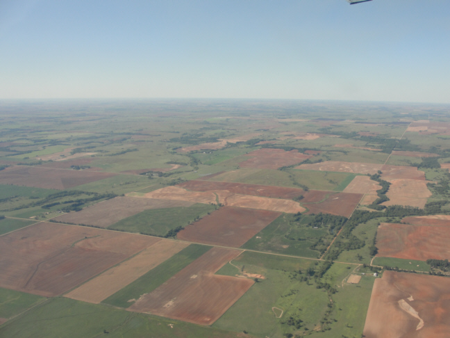
A shot of an abandoned farmhouse site in northern Clark County. In our flights over the state we have seen hundreds, if not thousands, of such sobering indications of what was once a more vibrant rural economy in Kansas.


Clark County is one of the great rock and fossil hunting regions in the state of Kansas, as seen by these rock outcroppings north of Ashland.

Ashland, Kansas. Founded in 1884 at the junction of the former Fort Dodge/Fort Supply Military Trail and the Sun City/Meade Center Trail, the county seat of Clark County boasts a population of just under 1,000 citizens. Learnin' stuff, aren't ya?


Harold Krier Field lies on the southern edge of the city of Ashland at an elevation of 1,951 feet above sea level. It opened in December 1945 on 180 acres and features two turf runways, one 3,135 feet long by 300 feet wide and the other 3,125 feet long by 300 feet wide. It is named after a national acrobatics champion whose airplane and trophies can be seen in the local museum in Ashland. We land at 2:40PM amid Tall Grass that causes the Pilot to momentarily misjudge the distance to the ground (Always mow your runways, you city officials out there!) and so we get to bounce again to another interesting stop.
Sigh.
We get out of our plane and conduct our checklist. Whenever we land we do have a checklist of 20 items, which helps to gather information on a particular airport that will be made later available for all pilots. The following is the checklist for Harold Krier Field: (1) Photograph from air - yes; (2) Weather radio reporting on ground - no [many airports have 24-hour automated weather reports that go out onto pilot radio frequencies]; (3) Windsock Condition - good; (4) Type of runway & condition - turf, 3135 x 300, tall grass!; (5) Fuel available & price - 100LL fuel, $4.05 a gallon, must call for someone to unlock gas pump; (6) Number of Hangars and Tie-downs - 4 hangars and 8 tiedowns [triangle-shaped spots where the ends of each wing and the back tire of one's plane can be roped/chained to hooks permanently positioned in the ground when leaving a plane outdoors for any length of time]; (7) Is there an airport attendant on the premises? - no; (8) Is there an available public telephone? - yes, but locked inside Airport Lounge [this is never good, because what if a pilot has no cell phone with them, or their cell phone does not work in this location, and they need fuel, or there is a real emergency?]; (9) Are there public bathrooms? - yes, but locked inside Airport Lounge; [Oh, that really helps, city officials! Thanks a lot!] (10) Is there an Airport Lounge/Terminal? - yes, but conventional key locked and so inaccessible to all pilots [Many lounges/terminals now have number-coded locks that are set to the Pilot Emergency Code Number, which all pilots know but the rest of the public will not and so keeps down on potential vandalism]; (11) Is there a courtesy computer available for pilots' use? - no; (12) Is there a courtesy television available for pilots' use? - no [both this and previous question are nice for pilots so as to check on the local weather]; (13) Are there any vending machines? - no [there is a water cooler locked inside the Airport Lounge, but is has long been empty of any water]; (14) Is there a courtesy car, taxi, or other available transportation for and there is a emergency, pilots' use to the nearest town? - no; (15) Are there any local brochures, listing attractions, food, and lodging? - no; (16) What is the airport's location relative to the nearest town? - southern edge of city of Ashland; (17) Nearest lodging - Red Hills Motel, Ashland; (18) Nearest food - Ranch House Restaurant, Ashland; (19) Cell phone coverage - Poor: T-Mobile, none, Verizon, one bar; and (20) Any hornets in the vicinity? - no. [This last was added to the list after that incident with the outdoor telephone at the Leoti Airport. But we're much better now.]
A great historic but little-known structure at Harold Krier Field is the sandstone-walled airplane hangar. We could discover nothing about it but thought it one of the neatest things we've yet seen at a Kansas airport; it is the only native rock hangar we know of anywhere. And, of course, we were so excited about it that we never took a photo of it. Sigh. But if you are ever in Ashland and have some time, go check it out. And if you learn of its history, please pass it along!

We happen to catch a city worker at the airport that had just finished mowing, but he did not have the keys for either the fuel or the lounge. So he calls another city worker, and in about ten minutes we are getting 11.6 gallons of fuel and using the amenities of the lounge [i.e., bathroom], which unfortunately does not include any water with which to quench our ever-growing thirst. AT 3:05PM we take off once more - and once more the Pilot radios that he is departing Bucklin air traffic. Sigh. Above is one last photo of Ashland.

We head east, and at 3:12PM pass over the disappearing community of Sitka, Kansas. Its post office closed in 1922.

The landscape in eastern Clark County now reflects the reddish soil that makes up the western fringes of the Red, or Gypsum Hills.

We pass over the Comanche County line and at 3:20PM fly over Protection, Kansas. Explorer Extra: This is the only town in the United States with that name. That one was for you, Marci.

A shot of downtown Protection. The gathering of cars in the street means that something is certainly going on!

Located three miles south of Coldwater, Kansas, the Comanche County Airport opened in March 1983.

We touch down at 3:30PM. The airport features a 4,500-foot x 60-foot concrete runway and lounge with bathrooms, but no public telephone and still no drinking water. This is starting to become a real concern!

Just to the northwest of the airport is Lake Coldwater, the only city, county, or state lake in southwest Kansas that allows swimming as well as boating, fishing and camping. It is a spring-fed 250-acre man-made lake in a 930-acre park within the Coldwater city limits.

We pass to the south of Coldwater, Kansas, population just under 1,000. Founded in the spring of 1884, the city is named after Coldwater, Michigan. The historic art deco Chief Theatre first opened in 1928 and is a must-see attraction!

In eastern Comanche County the Red Hills, also called the Gypsum Hills, dominate the landscape into the horizon.


There are several spectacular outcroppings in the Gypsum Hills. The Gypsum Hills Scenic Drive was recently named one of the 8 Wonders of Kansas Geography and and is easily one of the best such drives in the entire Midwest!

4:02PM - We approach Medicine Lodge, Kansas from the west. Settlers led by a man named John Hutchinson founded the town of Medicine Lodge north of the confluence of Elm Creek and the Medicine Lodge River in February 1873. The name comes from the medicine lodge, the mystery house or sacred tabernacle built by the Kiowa Indian Tribe, who had considered this site sacred due to the presence of Epsom salts here. The site is also famous for the Medicine Lodge Treaty, which in actuality was a set of three treaties signed between the United States of America and the Kiowa, Comanche, Plains Apache, Southern Cheyenne, and Southern Arapaho in October 1867. The site of the Peace Council camp was about three miles above that of the current town and on the same side of the river. A Peace Treaty Pageant, first presented in 1927, today is held every four years in an outdoor amphitheater at the southeastern edge of the city to commemorate this historical event.

Aerial view of the Peace Treaty Outdoor Amphitheater & Grounds (left) and Medicine Lodge Municipal Airport (right).

We touch down at Medicine Lodge Municipal at 4:24PM. To quote the fine folks at cyberlodg.com: "The Medicine Lodge Municipal Airport is an unattended facility adjacent to the Medicine Lodge Peace Treaty Grounds. Two turf runways and one paved runway allow the airport to accommodate small jets such as the King Air. At an elevation of 1,543 feet, the airport is host to home-based ultra-lights and visiting pilots who fly in for business related to agriculture or minerals and for the more daring souls who fly in for weekend hunting on some of the larger ranches in Barber County." Really. We look around; no available fuel, no public phone, no bathrooms, no drinking water. There is, however, excellent cell phone coverage. We take off at 4:27PM and continue east.

Just east of Medicine Lodge is this giant cardboard box evidently awaiting pickup by FedEx. Seriously, does anyone have a clue as to what the farmer was thinking when he plowed this field???

4:36PM - We pass to the north of Sharon, Kansas, founded in 1879 and the hometown of country music singer Martina McBride. The Wisner Library in downtown is located in a beautiful old brick building. Inside the library most of the books are kept in old glass-front wood cabinets.

To the north of Sharon is the Flat Ridge Wind Farm in eastern Barber County.

Attica, Kansas in western Harper County was founded in 1884 and named for the region in Greece surrounding Athens. Want something completely different to see here? Then ask directions to the city cemetery and find the tombstone inscription of a very politically-opinionated Union Army Civil War veteran buried there: "Through this inscription I wish to enter my dying protest against what is called the Democratic Party. I have watched it closely since the days of Jackson and know that all the misfortunes of our Nation have come to it through the so-called party - therefore beware of this party of treason."

Closeup view of downtown Attica, Kansas.
The landscape of Harper County, Kansas. "Organized in 1873, the organization of this county was one of the most glaring frauds ever perpetrated in the State. Attorney-General Williams, in his official report, says: 'It is not pretended that Harper County ever had an inhabitant.' The form of its organization was legal on paper, and that is all. In 1878 the organization became legal. The county was named in memory of Marion Harper, first sergeant of Company E, Second Regiment Kansas Cavalry. He was mortally wounded at Waldron, Arkansas, December 29, 1863, and died the following day. His comrades say he took his death coolly. When brought in wounded, he proposed a wager that in so many hours he would be dead; the bet was taken, and Marion Harper won." - Guest Text courtesy of History of Kansas, Noble Prentis, (Winfield: E.P. Greer. 1899).

The 127-acre Harper Municipal Airport first opened on June 1, 1947. The asphalt runway runs 3,268 feet long with a width of 38 feet. The turf runway runs 2,138 feet with a width of 160 feet. There will be a test on all this at the end of this blog entry!

4:52PM - On the ground at Harper Municipal. There is a lounge with bathrooms, and a vending machine for pop, but it is empty. Our thirst has now acute. We take off again at 5:08PM.


The Pilot is kind enough to circle the city so that the Official Photographer can take photos of Harper's claim to fame - the 9-foot metal fish weathervane was first placed on top of the just-completed Harper water tower on August 12, 1887. The vertical stand pipe watertower is 125 fteet tall and 16 feet in diameter. The octogon masonry base is 25 feet by 25 feet. The fish was a finalist for the 8 Wonders of Kansas Customs.

A last shot of downtown Harper, Kansas.

From Harper we turn south toward Anthony, Kansas - just seven miles away. This is the view south, both of Anthony Municipal Airport and the city of Anthony in the distance. Find the airport?

Here is a closer shot of it. The airport first opened in May 1941 and has an asphalt runway measuring 3,598 feet long by 70 feet wide.

Touch down occurs at 5:23PM. There is a lot of new construction work being done at Anthony Municipal. We walk down to the Airport Lounge, which has not been properly cleaned in a long, long time. It has a water fountain - WooHoo!!- but the fountain no longer works - 0)z#8$*)#4*$!!! - and with swollen tongues we assess the trip so far. Anthony is the tenth airport today (tying our previous record), and the wear and tear on our aging bodies in crawling in and out of the plane has taken its toll. You laugh, but you've not seen the videotape of what we go through in crawling in and out of the plane - and you're not going to either. Also, the Pilot is more than tired from all the flying. So we decide to forego our previous plan to land at Argonia, Norwich, and Wellington airports and decide to fly southeast to Wilcox Field, Caldwell Municipal, and then into Wichita, our overnight way. Our takeoff occurs at 5:40PM.

Aerial view of the city of Anthony, Kansas, established in 1878.

5:52PM - Okay, so here is what we know about the subject shown above: some eight miles to the southeast of Anthony Municipal is Wilcox Field, listed as a public airport not only on AirNav and several other websites but also on the State of Kansas Transportation Map. As we fly over it at 5:52PM the Pilot's reaction is "You're Kidding!", while my own reaction is something along the lines of Where is it . . . Wha . . THAT???!!"
We quickly look up this public airport and discover the following: "Surface: turf, in poor condition - ROUGH CULTIVATED FIELD", followed by "FARM ANIMALS OCCASIONALLY GRAZE . . . . "
So, with all due apologizes to airport owner Harold L. Wilcox of rural Anthony, Kansas, and to the various state and national agencies that have been lulled into believing this to be otherwise, we formally announce that for the purposes of our Quest we declare this runway to be By No Means A Public Airport, and that the number of Kansas public airports we need to land at to fulfill our Quest to be at 139 total. Anyone don't like it, then feel free to land here all you want. To paraphrase Ol' Waylon, we may be crazy but we're not insane!

5:55PM - We fly over the quiet Kansas town of Bluff City in southeastern Harper County.

6:10PM - we fly over the historic city of Caldwell, Kansas. It was founded in 1871 astride the then new Chisholm Trail as an economic adventure of a group from Wichita, Kansas. Caldwell boasted a longer cowtown period (1880-1885), a higher murder rate, and loss of more law enforcement officers than other more famous cowtowns. Being the first town north of Indian Territory, cowboys went wild in this untamed "Border Queen City" after months on the dusty and treacherous trail. Gunfights, showdowns, hangings and general hellraising were commonplace. From these true stories came the romanticized American cowboy and the love of the Wild West. In 1893 Caldwell was also a starting point for the famous Cherokee Strip Land Run, when Oklahoma Territory was opened for homesteaders to stake land claims. The historic tour is a must-see thing-to-do when visiting the Border Queen City. In 1986 the city was officially proclaimed "The Ornate Box Turtle Capital of the World."
Gee, and the town looks so peaceful!

Caldwell Municipal Airport opened in December 1945. It features a single 2,460 foot long by 110 foot wide turf runway.

6:14PM - And welcome to Caldwell Municipal. This is a shot of two of the airport's airplane hangars; what you don't see is the hangar behind you - the one with the ten foot-plus growth of grass and weeds blocking the doors! We endure a bumpy takeoff at 6:25PM and head northwest toward Wichita.

We fly over Wellington and much of Wichita and land at 7:10PM at Colonel James Jabarra Airport on the northeastern edge of Wichita. Big airport with all the amenities, including WATER!!! We tie down the plane, gulp and gulp water until finally satisfied, and then the Pilot places a call to his friend Bill Morris, with whom we are staying tonight.

Meet Bill Morris, architect, history buff and even briefly a baggage attendant. He will be our willing(!) host for the next several hours.

Whenever we visit Wichita Bill likes to give us something interesting to remember our visit by, and this time was no exception. Our "taxi" is a genuine authentic East German Trabant, the size of which one can judge by the Pilot standing next to it. To quote Wikipedia: "The Trabant is an automobile that was the most common vehicle in East Germany, and was also exported to countries both inside and outside the communist bloc. The main selling points was that it had room for four adults and luggage in a compact, light and durable shell and that it was fast (when introduced) and durable. With its mediocre performance, smoky two-stroke engine, and production shortages, the Trabant is often cited as an example of the disadvantages of centralized planning; on the other hand, it is regarded with derisive affection as a symbol of the failed former East Germany and of the fall of communism. It was in production without any significant changes for nearly 30 years.
Classic jokes concerning the Trabant: How do you double the value of a Trabant?: Fill up the tank!
What do you call a Trabant up a hill?: A miracle.
What do you call two Trabants up a hill?: A mirage. What do you call ten Trabants up a hill?: The factory's up there.
What's the best feature of a Trabant?: There's a heater at the back to keep your hands warm when you're pushing it.
What type of seats do you get in a Trabant?: Hammocks when you buy the EX model.
Why was the Trabant made?: There was a mistake, it was supposed to be a washing machine.
All joking aside, there is more room in the Trabant than there was in the Citabria. But not by much.

The Official Photograph of the Official Photographer and the Pilot upon the completion of their record-setting day of landing at no less than twelve new Kansas public airports!

My view from the back of the Trabant. Hmm, looks a lot like my view in the Citabria!
After a meal at a fine Italian restaurant we head back to the East Douglas Avenue home of Bill and his wife Sharon and their daughter Freya, where we alter our plans for the weekend. Originally we had thought to fly on to Lawrence, Kansas tomorrow and then back to Osborne on Sunday, September 5th. But now we have decided to stay tomorrow (Saturday) in Wichita and plan a new route for flying back to Osborne on Sunday. If the trip back was anything like the trip here, then I cannot wait!
After a meal at a fine Italian restaurant we head back to the East Douglas Avenue home of Bill and his wife Sharon and their daughter Freya, where we alter our plans for the weekend. Originally we had thought to fly on to Lawrence, Kansas tomorrow and then back to Osborne on Sunday, September 5th. But now we have decided to stay tomorrow (Saturday) in Wichita and plan a new route for flying back to Osborne on Sunday. If the trip back was anything like the trip here, then I cannot wait!
