Showing posts with label Osborne County. Show all posts

Friday, January 14, 2011

Just A Great Little Story From Yesteryear

     June 23, 1872—"Dan Otto, while quarrying stone north of the townsite [Osborne, Kansas], gets into a recontre with a buffalo, and commences retreating, but is overtaken by his pursuer, tossed over head and lights astride the animal’s hump.  With remarkable presence of mind the rider retains his position, while the frightening beast runs for miles to the northwest, and finally slackens its pace, when Daniel draws his revolver and discharges its contents into the vitals of his charger, which continues its course a short distance, and, stumbling in a ravine leading into Lawrence Creek, falls headlong in its dying struggles.  Otto, liberated, escapes.  (See Harper’s series 1872 for illustration.)  Our hero has returned to Pennsylvania."
     - Taken from Zachary T. Walrond's "Annals of Osborne County, Kansas, 1872" in the Osborne County Farmer newspaper of September 9, 1880.

Saturday, December 18, 2010

IN SEARCH OF: May 26, 2010 - Charlie Brenscom & The Great Indian Scare of 1878

THE SCENE:  For over a year I had been crisscrossing Osborne County, taking photographs of every tombstone known standing in the county. Now I was down to trying to locate those solitary stones rumored to be scattered here and there across farmers’ fields and ranchers’ pastures. Today’s hunt would be for the gravestone of Charlie Brenscom.

THE BACKGROUND:  Charlie Brenscom was an invalid living in Mount Ayr Township of western Osborne County when one of the more notorious incidents in Osborne County history occurred. What afterwards became known as the two days of “The Great Indian Scare of 1878” had its origins in late September of that year, when a band of Cheyenne Indians left their reservation in Indian Territory (today’s Oklahoma) to seek their old homelands in the Dakotas. They headed north through Kansas between Forts Wallace and Hays, throwing the western half of the state into a panic as one can imagine. The commandant of Fort Hays was unsure of the Indians’ intentions and as a precaution sent riders galloping east down the Saline and Smoky Hill river valleys to warn everyone of the potential danger.

Word reached Osborne County on October 7th via freight wagon drivers from Russell, Kansas, who by the time they arrived in the southern half of the county managed to change the message from “potential danger” to “they are coming!”

Now all of Osborne County was thrown into a panic. Stories abound both comic and tragic of the settler’s reactions over the next two days.  Former Civil War soldiers now homesteading the region took up their guns, organized under old officers, and took to roving the countryside searching for incoming war bands of Indians.  The dust rising from these roving soldier bands in the Paradise Creek region of southwestern Osborne County  was mistaken by other roving bands as being “the Indians – they are here!” and soon hundreds of people were tossing their belongings onto horses and into wagons and fleeing to the north and east. At Covert, halfway across the county, a funeral was being held when the news came. The mourners immediately fled northeast to the county seat of Osborne, leaving the unfortunate Mrs. Morris in her coffin still resting on two sawhorses, the pages of the Bible atop the coffin flapping in the breeze.

The domino effect continued. At Vincent in southern Osborne County a little girl mistook just cut stalks in a cornfield for Indian teepees and raced to town to warn everyone. Most of the community formed a small wagon train and fled northeast through the Blue Hills to the next small community of Potterville. Several men volunteered to stay behind and so give their loved ones a chance to get away. They raided the local general store for guns and gathered in Ira Pitzer’s stone house to make a last stand against the oncoming Indians. Only then did they realize that they had neglected to bring any ammunition along.

When the Vincent refugees reached Potterville that community was promptly abandoned at the news, the all-important post office was packed in a trunk, and still more wagons and people joined the growing train that now made its way fifteen miles northeast through the hills to the comparative safety of the town of Tipton in Mitchell County.

The Scare was in full swing by the time the news reached Osborne in the north central part of the county.  Five hundred settlers overturned wagons, barrels, and anything else they could find to build a barrier, quickly dubbed “Fort Osborne,” behind which they settled all that day and through the next night, waiting in vain for Indian warriors that never came.

The next day, October 8th, the word reaching far eastern Osborne County from fleeing refugees warned that “the entire Indian nation in the West was uprising” and that “three million Indians” were bearing down on the poor settlers, causing still more panic. But by October 9th things began to die down as people started realizing that no real Indians had actually ever appeared.  Sheepishly they began to return to their homes.  But not all.  The estimate is that approximately ten thousand people fled from Osborne County alone over those two days, and of that number nearly four thousand never came back. They had had enough of the "Wild" West.

In his 1882 “Osborne County Annals of the Year 1878” Osborne lawyer Zachary T. Walrond had this to say about the Scare: “October 8th: There is a great scare in the western part of Osborne County, the alarm originating from a rumor that the wild Indians are raiding down Paradise and Eagle Creeks; five hundred settlers go to the defense of Osborne. Chas. Branscomb [sic], an invalid, dies while his friends are removing him to a place of safety.”

Which brings us back to Charlie Brenscom.

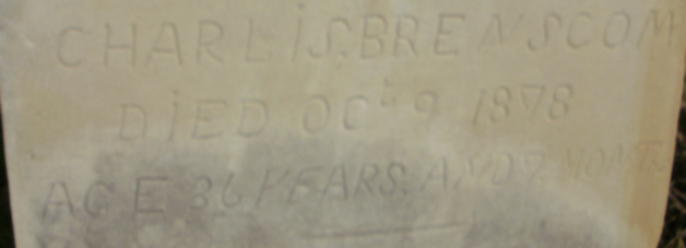
THE SEARCH:  What I had to go on to find Charlie Brenscom's gravestone came from two sources.  The first was Mrs. Auldin Conrad, who lives across the road from the Fairwest School, District #38, a long-abandoned frame one-room rural schoolhouse still standing in the northeast quarter of Section 25 in southeastern Mount Ayr Township.  Now well into her 80s, Mrs. Conrad had just a few years ago had told me that the stone was still to be found "just behind the schoolhouse" and then told me the wonderfully absurd story passed down in the area that periodically Indians used to stop by Charlie's stone, and after they left the local people would come and poke around the grave, thinking that the Indians might have buried treasure there.  My second source was the above photo, taken in 1977 of the headstone by the Osborne County Genealogical & Historical Society, showing the Fairwest schoohouse in the left background.  The closeness of the stone to the school in the photograph made seem that this stone would be easy enough to find.

So 23 years after that last photograph I and my recruited help, Merlyn Brown, owner of Osborne’s Merlyn Entertainment Group graphic arts company and an avid photographer by trade, found us driving the gravel roads of Mount Ayr Township toward the Fairwest School, seen here in center background.


The night before I had tried to contact Randy Conrad, the local landowner, to let him know that we might be out and about on his land around the schoolhouse, but had no luck in reaching him.  In our confidence on knowing local customs and figuring that if we ran into Randy we could let him then know what we were doing, we proceeded with no guns or bags, only cameras, in trespassing on his land - you kids reading this at home should NEVER do this.  We were wrong and I apologize here to Mr. Conrad and to all rural landowers for our arrogance.   And yes, we paid for it.

Mrs. Conrad had said that the stone was "just behind the schoolhouse."  Well, it wasn't.  We searched and searched, getting into some pretty rough overgrowth that stood taller than what the gravestone probably was.  In the photo above the Fairwest School can just be seen to the left of the trees in the far background.

We continued to search in this overgrowth for nearly an hour in vain.  If the stone was here it might be knocked over by now, and if that happened in this growth then there was no way to find it - unless one literally stumbled over it. 

Over an hour later we were well to the south of the schoolhouse.  No gravestone.  Nothing else of worth to even photograph.  Nothing but sweat, bites, welts, and a couple of small cuts to show for our efforts. 

Taking a look at that 1977 photograph again, this time it registered that the stone might not behind the schoolhouse, but more to the south of the school.  As in the next field?  Merlyn went ahead of me, and sure enough, there was the grave.  Hey, Merlyn, look behind you!

Charlie Brenscomb's grave lies at least a quarter mile south and just a smidgen west of the schoolhouse in the middle of a corn field.  Just to the right of Merlyn's camera you can see the Fairwest School.

Considering its age (129 years), Charlie's native limestone, handcarved headstone is in remarkable shape and still quite readable.

We take one last photograph of Charlie's grave, secure in the knowledge that it was still to be found in the year 2010. 

Flush with success, we head south to Natoma in southwestern Osborne County and stop at the cemetery there.  Why?  Why, so Merlyn can take photos of horses, of course!

Actually, there was one more tombstone that I needed a good photograph of in the Natoma Cemetery.  For this region the stone on Ken and Leah Griffin's grave is a bit unusual!

We then turn east from Natoma down Kansas State Highway 18 under a beautiful sky.  We are approaching the town of Paradise, Kansas.

In approaching Paradise one cannot help to see the iconic 1888 Post Rock Limestone city watertower.

Now, if one kept going on down Kansas State Highway 18 one will eventually come to the Garden of Eden, in Lucas, Kansas.  Russell County, Kansas - one of only two places I know in the world where one can find in close proximity Paradise and the Garden of Eden!

Needing to get back to Osborne, we take the opportunity to drive down a few Kansas backroads so that I can take Merlyn to the Cedar Bluff Cemetery in central Osborne County, as he had never been there before.

And he was immediately captivated.  What is he taking a photo of??

Ah.  I see.

Cedar Bluff Cemetery is noted for the large cedar trees that tower over the cemetery.

Here in late May older strains of the iris flower abound around 120-year old graves.

Even the summer lilac can be found here!

This is the road into the cemetery.  Some people, upon seeing it, might just be a little bit hesitant . . . . 

 . . . . especially when they see the old 1920s era bridge they have to cross!

The bridge spans Covert Creek, which is flowing nicely due to recent rains in the area.

And here the summer lilacs can really be found in full bloom!

Reluctantly the day was ending, and we would have to wait until another day to once again explore the backroads of Osborne County!

Wednesday, December 1, 2010

DO NOT PANIC!!!

"DO NOT PANIC!  PLEASE REMAIN CALM!" - from the movie Animal House (1978).


It SEEMED like a good idea at the time.

They THOUGHT it would be easy.

For those of you who are still worrying about THIS year and have not been paying attention, next year is the 150th birthday of Kansas.  For some months various state officials and agencies have been wracking their brains trying to think of ways to celebrate this important milestone - cheaply, of course.  

And on November 5, 2010, the following email was sent out across the state:

"Dear Genealogists and Historians,

In commemoration of Kansas’ 150th Birthday and in conjunction with Savor Kansas and Visit Topeka Incorporated, Kansas Network to Freedom is holding a drive to collect local Kansas history for the Kansas 150th Commemorative Calendar.

We are asking every county and/or local society to contribute important dates, pictures of important historical figures and places, and information about their local history to include in the calendar that will be available at the 150th Celebration in Topeka on January 29th, 2011.

Submissions should be sent as attachments via email. Deadline for submissions is November 20th. Selections will be chosen from submissions sent in by the due date. If you have any questions please email or call Sherri Camp. See my information below.)

To contribute, send email to:
Sherri Camp, President
Kansas Network to Freedom
785-969-9144
sherri@kansasnetworktofreedom.com

Thank you,
Sherri Camp"


Now, to the average layman 15 (fifteen) days would no doubt seem like plenty of time to compile such a list of dates, events, and photographs from every county.  They all have them just lying around already compiled, right?

Unfortunately, no.  Most counties don't have anyone who has sat and thought out such things.  Oh, they might remember such events as when the county was formed, and when the county celebrated its centenary, but that is pretty much about it.  And as to the actual dates?  And photos as well?  All that takes time to gather - say, six months, or more. 

And here you have been given 15 (fifteen) days. 

Now imagine what the Osborne County Genealogical & Historical Society thought when they read this email.  Like most of the small, local, all-volunteer-run such organizations across the state of Kansas, the OCGHS does not have someone reading the emails each and every morning.  Truth be told, they are lucky to have volunteers to even man the Society's office/archives for a few hours on any given day.  So when this particular email was read on November 18th - yes, November 18th, as in two days before the deadline for submissions - one can imagine the panic that set in.  After all, they want to be included in this celebration of the state, but - !

Years of being a state representative allowed OCGHS president Laura McClure to marginally control her personal panic enough to quickly send out emails asking for help in the matter.   

As one can imagine, the emails flew back and forth fast and furious.  No one - in Osborne County, at least - had ever sat down and compiled such a list of important events from throughout the county's history.  And we are talking about combing through the county's entire 140 years of political, social, and economic legacy in just two days to make such a list!  What events are important enough to be included?  Usually a year can be found for when events occurred, but what were the actual dates?  And where do you find these at?  And what events are important enough to be included?  And photographs, if available, would need to be found and copied.  And what events are important enough to be included?

And so it was with some relief (and great coincidence) that on that same day - November 18th - a second email was received announcing that the deadline for submissions was extended to December 1st.  Evidently the uproar had not come from Osborne County alone.  Still, that only left 12 (twelve) days in which to compile such a submission. 

So books were pulled, photographs and CDs of scanned photographs perused, the poor people at the county courthouse in charge of maintaining the county records duly harrassed, and every site on the Internet dealing with Osborne County history was consulted, and in 12 days 36 points from the county's past were brought forth.  Of these, two dates could not be confirmed in the time alloted, so they were dropped, leaving just 34 items from the county's 140 years of existence to be shared with the rest of Kansas. 

The following is the 34 entries sent in, along with the two not submitted - still great events in their own right - by the Osborne County Genealogical & Historical Society.  While the list does give some insight into this typical Rural Kansas county's legacy (as well as the mindset of those who compiled the list) please keep in mind that this list merely scratches the surface of this county's rich history, and in no way should be considered the final product:


           Important Historical Dates - Osborne County, Kansas:

July 21, 1866 – Irish-born U.S. Army soldier Edward Roche of Company I, 2nd U.S. Cavalry, is killed by Indians along Twin Creek while escorting the party surveying what will later become Osborne County. They bury Roche at what later becomes the common corner of Corinth, Penn, Winfield and Bloom Townships; he is later moved to the Osborne City Cemetery.

March 3, 1867 – Kansas Governor Samuel B. Crawford officially names Osborne County in honor of Captain Vincent B. Osborne, a Civil War veteran who lost a leg in a battle on January 17, 1865.

January 14, 1870 - The first homestead in Osborne County is settled on by George Wolberd in the northeast corner of the county, in Section One of what later becomes Ross Township.

March 4, 1870 – Charles and William Bullock settle on claims in what later becomes Tilden Township, where they erect Bullock’s Stockade, the first permanent settlement in Osborne County.

July 2, 1870 – The Last Indian Raid in Osborne County takes place by a band of approximately 50 Indians at Bullock’s Stockade. Two Indians are killed in the brief skirmish.

August 10, 1870 – Around this time Dr. Daniel Tilden arrives in Osborne County to claim a homestead in what later becomes Tilden Township. In the spring of 1871 he lays out and plats the townsite of Tilden on his homestead. In 1874 the town’s name is changed to Bloomington.

September 12, 1870 – Founding of the town of Bull City by Hiram C. Bull and Lyman T. Earl. A coin toss determines the name of the town. In 1885 the town’s name is changed to Alton.

November 8, 1870 – Founding of the town of Arlington by Calvin Reasoner and others and opening of the Reasoner-Thompson General Store.

May 1, 1871 – Founding of the town of Osborne City by the Pennsylvania Colony. By the early 1890s the “City” is dropped from the name.

June 2, 1871 – Founding of the town of Bethany, named by Zachary T. Walrond, and opening day for the Bethany Post Office. In 1880 the town’s name is changed to Portis.

June 3, 1871 – Meeting for the formal organization of Osborne County is held at Arlington on the steps of the Reasoner-Thompson General Store.

October 29, 1871 – J. B. Emley begins touting his new town of Emley City, at the center of Osborne County in what later becomes Independence Township, as the perfect site for the permanent county seat. In 1873 the town’s name is changed to Centerville. In 1876 it is changed again, this time to Bristow.

April 2, 1872 – Fourth and final election for permanent Osborne County Seat. Osborne City receives 267 votes to Arlington’s 214.

June 19, 1873 – Arrival of Henry and Rosa Ise at Henry’s homestead in Ross Township of Osborne County. The story of their life on this homestead, Sod & Stubble, written by their son John Ise, was first published in 1936.  Still in print 75 years later, the book is considered a classic on the homesteading era of the Great Plains of North America.

March 22, 1877 – Arrival of Howard Ruede on his homestead in Kill Creek Township of Osborne County. The story of his life on this homestead, Sod-House Days: Letters of a Kansas Homesteader 1877-78, was first published in 1937. Still in print nearly 75 years later, the book is considered a classic on the homesteading era of the Great Plains of North America.

June 5, 1879 – The townsite of Downsville is platted by landowners John Bea1, Azariah & Marinda Blunt, Mrs. Harriet DeLay, with Missouri Pacific Railroad president R. M Pomeroy in Sections 28 and 29 of Ross Township. Within six months the town’s name is shortened to Downs.

October 12, 1879 – Osborne County State Representative Hiram C. Bull and two other men are attacked and killed at Bull City by Bull’s pet elk. The sensational event makes national headlines and the subsequent funeral draws approximately 2,000 people. It is still considered the largest funeral ever held in northwest Kansas.

October 19, 1880 – The townsite of Covert is surveyed and laid out in central Osborne County, with a plat of the town being duly recorded on October 26, 1880.

May 1, 1887 – What is considered to be the first self-driving vehicle ever built in Kansas is invented by Osborne City blacksmith Frank Hatch. The vehicle consists of a wagon propelled by a four-cylinder vapor engine. It is driven that spring and summer through the streets of Osborne City and the surrounding countryside before being dismantled.

October 15, 1888 – The Union Town Company surveys and lays out a plat for the new town of Natoma in the southwest corner of Osborne County.

November 1, 1901 – Around this time is the establishment of Meades Ranch in Delhi Township, Osborne County as the Geodetic Center of North America. This unique and important scientific site is the reference point for all property lines and city, county, state and international boundaries on the North American continent that are tied to the national triangulation networks of the United States, Canada, Mexico, and Central America. It was renamed the North American Datum in 1927.

May 29, 1904 – Birth in Downs, Kansas of psychiatrist Dr. Robert Hanna Felix, creator of the National Institutes of Mental Health.

June 8, 1904 – Birth in Alton, Kansas of internationally-acclaimed architect Bruce Alonzo Goff.

January 25, 1907 – John Locke, 1976 National Basketball Coach of the Year and the winningest high school basketball coach in Kansas history, is born on the family farm in Kill Creek Township of Osborne County.

October 7, 1912 – The original landowners relinquish all rights to a 40-acre tract around the Seventh-day Adventist-operated Hill Agricultural Academy in eastern Bethany Township. The land is laid out and platted as the townsite of Academy.

April 26, 1929 – Osborne High School junior Fred Stambach Jr. makes a high jump of six feet, 3.5 inches at the county track meet in Downs. With this one jump Stambach breaks six records – the school, county, district, state, national, and world’s interscholastic records. Though his world record is beaten just 24 hours later, Stambach’s jump stands as the Osborne High School record for the next 70 years.

September 22, 1943 – Crash of a B-24 bomber from California to Topeka, Kansas in southern Covert Township of Osborne County, killing eleven military servicemen aboard.  In April 2004 a memorial was dedicated at the site to their memory.

October 19, 1968 – Agra High School’s football team defeats Alton High School 19-13, ending Alton’s six-year, 51-game winning streak. The streak was the all-time state record for most consecutive football victories for nearly 35 years and for three decades was among the Top Ten such streaks nationally as well.

May 22, 1970 – Last day of classes for Oakdale School, District #3, in Ross Township. This was the last one-room rural schoolhouse in Osborne County.

October 14, 2000 – Osborne High School senior Brittany Dietz wins her fourth straight Class 3-2-1A girls’ tennis championship. She finishes her high school career with the all-time state high school single-season record of 43 wins (1997) and the greatest all-time career record of 149 wins and no losses.

March 27, 2003 – Osborne High School senior Brooke Ubelaker is named Miss Kansas Basketball. In four years she led the Bulldogs to a 99-5 record, two state championships, and two state runner-up finishes.

November 27, 2003 - Acknowledging Osborne County as the home of two famous books on the homesteading era of the Great Plains of North America, the Osborne County Commissioners adopt a proclamation designating Osborne County, Kansas as "The Homestead Literature Capital of Kansas."

April 2, 2007 - The Kansas Senate passes Senate Resolution No. 1859, declaring that the "Sod & Stubble Country Self-Guided Tour" in Bethany and Ross Townships of Osborne County to be an official state heritage tour.

April 25, 2008 – The century-old Osborne County Courthouse is named one of the 24 finalists for the 8 Wonders of Kansas Architecture contest. The building is selected as being the best example of James Holland-designed courthouses in the state.

 
[And here are the two deleted entries, again only because the exact dates were not able to be found in the time allotted:]

1880 – While digging a well in Section 27 of Hawkeye Township a man uncovers what he believes to be gold nuggets. Word quickly spreads to the nearby community of Bloomington, and the great Bloomington Gold Rush of Osborne County is on. Hundreds of area farmers immediately converge and illegally begin digging in and around the homestead where the strike occurred. The next day two experienced miners now farming in the area examine the original rocks and determine that they are indeed pieces of pyrite, or “fools gold,” effectively ending the rush.

1904 – Bert Walker buys the Osborne County Farmer newspaper in Osborne. Together with Farmer editor and Kansas Speaker of the House of Representatives Charles Mann, the newspaper over the next 44 years becomes for a time the most influential weekly small town newspaper in Kansas.

*  *  *  *  *

To sum it all up:  if anyone out there of any influence or position has been reading this, please in the future take the time to truly consider what you are asking and to properly think it all through first.  You are driving the volunteers - that are driving this state in the first place - absolutely nuts!


Sunday, July 18, 2010

The July 17, 2010 Ascent of the Eastern Face of Mount Os. Loss of Life: Minimal.

     The pretty-much-unheard-of Mount Os Expedition of 2010 unfortunately received virtually no publicity anywhere whatsoever.  This led to several desperate attempts by one of the members of the Expedition at faking widespread interest in the story - an example of which is this pathetic ripoff of a 1923 National Geographic Magazine cover - in hopes of creating the impression that the world had watched with rapt attention while the melodramatic details of this near-adventure unfolded.  Pity (in the form of a few hundred bucks slid under the table and a couple of cokefloats slid over the table) led to our allowing excerpts of the long-winded Tale of the Expedition to be printed here - and probably, for that matter, for the first time anywhere else as well. 
* * * * *

 - PART I -

Planning the Expedition to
the Highest Point in Osborne County, Kansas

     Mount Os [pronounced aaawwwzzzzz].  2,088 feet above sea level.  A once-mythical Kansas summit that remained elusive to geologists, adventurers, and soil conservation groupies throughout the county's first 138 years.  Oh, sure, you could ask just about anywhere and find out the Lowest Point in Osborne County, Kansas ("Why, that's where the North and South Fork Solomon Rivers both flow out of the county at its eastern border, sonny - everyone knows that!").  Despair at ever finding the Highest Point,  however, seemed the general rule of the day. 
      Until January 2010, that is, when mild-mannered local historian and avid Kansas Explorer Club member Von Rothenberger announced to a innately disbelieving and skeptical local citizenry that he had found it.  At an email news conference he cited twenty years of pestering the same people with the same endless question and delighting in reading countless old discarded county topological maps, all of which finally culminated in one long 28-hour-long-session-spread-over-two-days of comparing twenty years' worth of carefully documented notes with a wonderful new Internet research tool called Google Earth to discover the location of the physical structure of Mount Os. 
    A few moments of silence were then explosively shattered by an almost immediate firestorm of comments.  "I thought it would be elsewhere."  "You sure? That rise to the north looks higher."  "This can't be it - your computer must've been wrong."  "You sure? That rise to the south looks higher."  "Aaaw, that can't be it!"  "What about Pilot Mound? And Sand Mound? And  . . . !"  And so on and so forth for the next several months.
     Undaunted, Rothenberger hid under his bed and layed low and the uproar slowly faded away.  Then word was secretly sent out and three groups that eventually made up our Crack Climbing Team assembled at the Peace Lutheran Church in Natoma, Kansas.  This became known under the code name of Natoma High Camp.
    
     An example of the meticulous undercover planning that went into this Expedition can be seen by this never-before-seen napkin map, which was created after the Expedition was over.  It shows the best suggested route for Expedition Groups A & C to travel from the Expedition's Base Camp, which was established at The New Place in Luray, to the fluid location of the Natoma High Camp.  Also given is the potential site from there of Mount Os.  Secrecy was such among the Expedition members that neither Group A - "The Wild Bunch" - nor Group C - "The Woolly Bunch" - were aware of each using this route at relatively the same time. 

     The Expedition's Crack Climbing Team assembled at last in a secreted basement compound far beneath Natoma High Camp.  Groups A & C were joined here by Group B - "The Native Guides", and Group D - "The Lone Explorer".  Don't let the jolly dispositions and doughy physiques fool you; these highly untrained professionals were invited to be part of the Expedition through their many years of negotiating the sometimes-rugged hills and always-deep gullies of the Blue Hills Highlands.  Our Crack Climbing Team experienced several minutes of training for the ardous rigors of the Expedition and needed only a few more minutes to settle on the best approach to scaling Mount Os, via the East Face. 
     Oh, and they also decided to co-sponsor the General Bull's Revenge Supper to be held the night of Saturday, October 16th at the Homestead Restaurant in Alton.  Be there or be square!

     The above Google Earth topological map displays the Expedition's agreed-upon plan for the Approach.  By driving County Road 657 south from Natoma High Camp approximately three miles, then turning left (west) onto West 290th Drive for .75 miles into the Eastern Face of Mount Os, they hoped to save countless needless hours of walking to the summit.  It was a bold plan and one full of hot wind and little water.

     Layed out here is the massive assemblage of Kansas-oriented mountaineering equipment carried by the Expedition: (a) Standard U.S. Flag for planting on the summit; (b) one hand-carried thermometer for up-to-date readings on the extreme conditions to be found on the summit; (c) one can of OFF to ward off the insidious giant varmints known to infestate the Mount Os region; (d) Standard Topographical Map for the vaguely exact locating of the summit; (e) Duct Tape - 'nough said; (e) Standard St. Mary's Safari Hat, to pretend that there is someone in authority in charge of the Expedition; (f) Standard Sunflower Visor, for identification to other would-be climbers that THIS is an All-Kansas Expedition; (g) Standard Black Umbrella, for . . . er . . . well, something; and finally (h) A Top-Of-The-Line Insulated Jug for carrying either cool, cool water or hot, hot coffee - depending on the extreme conditions to be found on the summit.

     Shown here are the Standard Alpine Climbing Boots inexperienced mountain climbers use when attacking the unknowable heights of Kansas summits.  Nearly a third of the Expedition were shoed with this latest high-tech equipment.  The rest had heels.  And sandals.  Sigh.

* * * * *
- Part II -
Our Crack Climbing Team


Adeline Eickhoff – Native Guide, Our Russellian Translator

Betty Pruter – Native Guide, Our Alton/Osborne/Natoma Dialects Expert, Meteorologist

Carolyn Williams – The Lone Explorer, Moralegist

Eileen Wilson – Woolly Bunch, Moralegist

Joe Hubbard – Wild Bunch, Logistics and Supply

Kathy Bristol – Wild Bunch, Still Photography, Hydrologist

Laura McClure – Wild Bunch, Communications Expert, Transportation

Mildred Morgan – Woolly Bunch, Moralegist

Orville Pruter – Native Guide, Our Ellisian Translator

Bob Eickhoff – Native Guide, Our Rooksian Translator

Russell Phalen – Wild Bunch, Senior Porter, Equipment Maintenance

Von Rothenberger – Wild Bunch, Expedition Leader, Photo-Journalist, Cartographer

     All plans having been made and all potential hazards assessed, the Expedition ran one more run-through of all needed baggage and settled into three post-selected Expeditionary vehicles.

Part of the baggage and equipment prepared for the Expedition.

 
     There was a tense moment when the Native Guides engaged in an animated conversation as the rest of Expedition members waited in their air conditioned vehicles.   The Natoman dialect is difficult for the average ear to pick up, but the discussion seemed to involve reciting the recent history of a local spirit named "Tucker."  Eventually the proper phrases were said and the Expedition could continue.

*  *  *  *  *
- PART III -
The Approach!

The temperature sat at 105 degrees as we left Natoma High Camp and began the climb in elevation.

     From the inside of our state-of-the-art SUV our high-tech meteorogical equipment informed us that as we have climbed a few hundred feet higher the temperature outside had indeed dropped to a more reasonable 100 degrees.

     Indeed, only a few minutes later the temperature had fallen to a balmy 99 degrees - by Kansas standards just another typical July day!

     Sure enough, one look outside the titanium-tinted window proved that we indeed had climbed above the treeline.  We were getting near our objective!

*  *  *  *  *

- PART IV -
At the Summit! 
 
     Go on, pinch yourself - in this photograph you are actually looking south from the summit of Mount Os.  Mount Os can be technically described as being a "mesa summit" - that is, flat-topped and wide.  This explains part of the visual concerns by visitors, where it seems that the ridges in the distance are higher than the central location.   This mesa summit covers approximately .75 miles in area.

     A Meteorogical Station has been established at the Mount Os summit, with a rain gauge that will keep records of rainfalls going all the way up to four inches!  Technology is a wonderful thing. 
     NEXT:  A wind gauge would be nice.  The wind at the summit was unrelenting, howling across Mount Os at thirty miles per hour and threatening to cast dust all over Expedition's Summit Camp.


     Just as the U.S. Marines raised the U.S. Flag at Iwo Jima in this famous photo from World War II . . . .
     So did two of our Native Guides, Orville Pruter and Bob Eickhoff, raise the U.S. Flag at the summit of Mount Os.  There was not a dry eye among the Expedition at this moment. 
 
     It was a moment to remember - the U.S. Flag waving at the summit of Mount Os, 2,088 feet above sea level, the Highest Point in Osborne County, Kansas.  The once-mythical site is now a piece of Kansas Explorer lore!

     Here they are! They've Done It! Hot, Sweaty, Exhausted, & Windblown - but Exhilarated! The Expedition Members have reached the highest point in Osborne County, Kansas!   They are seen here standing at the summit of Mount Os for the Official Photograph.  This is the moment the Team will remember for at least the rest of the week.  Absent are Kathy Bristol, who is taking the photo, and Joe Hubbard, who was overseeing the Summit Camp. 
      And in the end, the enduring question remained:  why find and climb Mount Os in the first place? 

BECAUSE IT WAS THERE!!!

 
     Back at Base Camp, The Wild Bunch lives up to its name as it celebrates the Expedition's amazing accomplishment with the tossing back of one or two badly needed drinks. 
 
     As the sun goes down on another great Kansas July day, who knows what other new exciting adventures are still out there to be found in for all Explorers in Osborne County, Kansas!